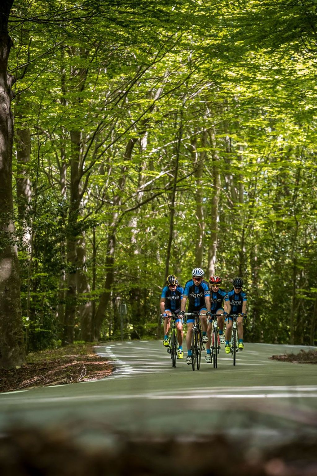
Lloret de Mar - Turó de l’Home - Lloret de Mar
Lloret de Mar - Turó de l’Home - Lloret de Mar
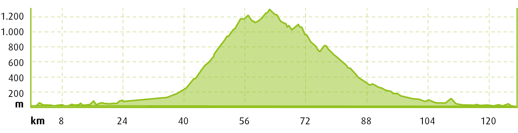
 Distance:
140 km
Distance:
140 km
 Elevation gain:
1.850 m
Elevation gain:
1.850 m
 Max. Elevation:
1706 m
Max. Elevation:
1706 m
Water points
- Blanes
- Hostalric
- Sant Celoni
- Mosqueroles
- Santa Fe
- Arbúcies
- Hostalric
- Blanes
|
MOUNTAIN PASSES |
CATEGORY |
DISTANCE |
ELEV. CHANGE |
AV. GRADE % |
MAX. GRADE % |
||
|
Turó de l'Home |
HC |
22KM |
13,67 MI |
1490M |
4888 FT |
6,5% |
14% |
|
SECTIONS WITH TRAFFIC DENSITY / ROAD SURFACE DEFECTS |
HIGH DENSITY |
MEDIUM DENSITY |
LOW DENSITY |
|
Lloret - Blanes |

Urban and inter-urban section |
||
|
Blanes - Sant Celoni |
Caution! Fast road with dense traffic |
||
|
Sant Celoni - Arbúcies |

Secondary road Asphalt in poor condition for the final 4 km before reaching Turó de l’Home. Caution! |
||
|
Arbúcies - Blanes |

Road with wide hard shoulder |
||
|
Blanes -Lloret |
Urban and inter-urban section |
Departing from the Central Tourist Office of Lloret de Mar located in Carrer de les Alegries, 3, we follow the south exit from the city along the GI-682 road in the direction of Blanes.
This is a section of road with considerably heavy traffic that should be avoided at rush hour, from 8 am to 9.30 am and from 5 pm to 7 pm.
We leave Blanes behind and take the GI-600 in the direction of Tordera. This road will take us to Hostalric. We take the C-251 in the direction of Sant Celoni. Caution! This is a section of road with considerably heavy traffic that should be avoided at rush hour.
Once we reach Sant Celoni we take the Sant Celoni Nord turn-off and follow the signs to the Montseny Natural Park, taking the BV-5114 road in the direction of Santa Fe. We reach a roundabout and take the BV-5119 road in the direction of Mosqueroles. Here begins one of the longest, toughest and prettiest climbs in the entire country: the climb up to Turó de l’Home, the only hors catégorie mountain pass that doesn’t belong the Pyrenees, with more than 1,500 metres of elevation change in 22 km. It’s the Catalan version of Mont Ventoux!
After 15 km we come to the turn-off that leads right to the summit of Turó de l’Home along an extremely tough 6.5 km, passing through a barrier at the final kilometre. Heading back, we continue along the BV-5119 road as far as the link to the BV-5114 road that will take us to Santa Fe. Take care! The road surface has been repaired but is not 100% smooth for a fast descent.
We continue along the road, riding through some spectacular beech forests as far as the crossroads with the GI-543 road, which we take in the direction of Arbúcies, completing a superb descent of linked bends with very little traffic.
We cross the town of Arbúcies and take the GI-552 in the direction of Hostalric. Here we take the BV-5122 in the direction of Tordera, crossing the town, and then the B-600 in the direction of Blanes, along the same section we headed out on.
From here, we have an enjoyable ride on the GI-682 road that leads all the way back to Lloret de Mar, the start and end point of the route.
It’s important to bear in mind that the temperature at the summit of Turó de l’Home, at an elevation of 1,706 metres, is substantially lower than in the valleys in the spring and autumn. The descent can be tough if you’re not properly kitted out.
Points of interest
Montseny Natural Park: declared a Biosphere Reserve by UNESCO, it’s a mosaic of Mediterranean and Central European landscapes. With extraordinary biodiversity and an important cultural legacy left by humans over time, this is an incredibly valuable area that has inspired artists, intellectuals and scientists, thrilling those who come to visit it.
Santa Fe: Santa Fe is the name of a small valley at an elevation of 1,300 m, surrounded by beech forests. It’s one of the best-known areas of the Montseny Massif. At the turn of the 20th century a lake was built there, integrated in the natural surroundings, and a hotel was built next to the ancient Romanesque chapel of Santa Fe.
Turó de l’Home: at an elevation of 1,706 m above sea level, this is the highest peak of the Montseny Massif. The summit was used as a military base and a weather station in the past and part of these facilities can still be seen there. This vantage point offers a wonderful view of the Pyrenees and the Mediterranean Sea. On clear days you can make out the Serra de Tramuntana, a mountain range in Mallorca.
Arbúcies: the streets of this town at the foot of the Montseny Massif are filled with flower carpets and floral art at the end of May or in early June when it celebrates the Enramades (decorative garlands) festival, declared a traditional festival of national interest.